Drones use GPS, sensors, and cameras to navigate terrain 75%
Unlocking the Secrets of Drone Navigation
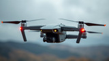
As we step into an era where drones are increasingly being used for a wide range of applications, from aerial photography to package delivery, understanding how these unmanned aerial vehicles navigate terrain is crucial. The ability of drones to navigate and map out their surroundings using various technologies has made them an indispensable tool in many industries.
How Drones Use GPS
GPS technology plays a vital role in enabling drones to locate themselves in space and determine their position relative to the Earth's surface. By using a combination of satellite signals and onboard navigation systems, drones can calculate their exact location and velocity with high accuracy. This information is then used to guide the drone through its flight path.
The Role of Sensors
In addition to GPS, sensors also play a crucial role in helping drones navigate terrain. These sensors detect changes in altitude, pitch, roll, and yaw, which are essential for maintaining stability and control during flight. Some common types of sensors used in drones include:
- Accelerometers
- Gyroscopes
- Magnetometers
Capturing Terrain with Cameras
Cameras on a drone serve multiple purposes, including capturing high-resolution images and video footage, as well as providing visual data to aid navigation. Camera-equipped drones can detect and respond to their surroundings by analyzing the visual information they collect. This technology is particularly useful for applications such as surveying, mapping, and search and rescue operations.
Conclusion
The ability of drones to navigate terrain using a combination of GPS, sensors, and cameras has revolutionized various industries. As technology continues to advance, we can expect even more sophisticated drone navigation systems that will further enhance their capabilities and open up new possibilities for applications.
- Created by: Kabir Kumar
- Created at: Aug. 10, 2024, 9:55 p.m.
- ID: 6656